
El Nino and Weather Impacts in Brevard County, Florida |
How La Nina and hurricane season Brevard County influence local climate patterns |
The National Oceanic and Atmospheric Administration (NOAA) has announced the conclusion of the La Niña climate pattern, with expectations of an El Niño developing later this year. The strength of this impending El Niño remains uncertain.
NOAA's recent declaration marks a significant shift in global climate patterns, raising concerns about potential impacts on global temperatures. The transition from La Niña to El Niño could have profound effects on weather systems worldwide, including the Atlantic and Pacific hurricane seasons.
Some climate models suggest that the forthcoming El Niño could be exceptionally strong, potentially qualifying as a "Super El Niño." However, federal scientists refrain from using this term officially. Historically, strong El Niño events have been associated with record-breaking global temperatures, such as those observed in 2024. Forecasters are concerned that a robust El Niño could lead to unprecedented global heat levels extending into 2027.
Currently, the planet is in an intermediate phase known as "ENSO-neutral." The recently ended La Niña began in December 2024, characterized by cooler Pacific Ocean temperatures. This pattern influenced rainfall distribution, leading to increased dryness in the southern United States and slightly cooler global temperatures compared to El Niño years. La Niña also contributed to a more active Atlantic hurricane season and colder winters in parts of the northern U.S.
El Niño is a natural climate phenomenon where surface sea temperatures in the central and eastern tropical Pacific Ocean are warmer than average. The term, meaning "The Little Boy" or "Christ Child" in Spanish, was first noted by South American fishermen in the 1600s due to unusually warm Pacific waters around Christmas. The entire cycle, known as the El Niño–Southern Oscillation (ENSO), alternates between warmer (El Niño) and cooler (La Niña) phases along the equatorial Pacific.
While NOAA does not officially categorize El Niño events as "Super," the term is often applied when sea-surface temperatures in the tropical Pacific are up to 2 degrees Celsius above average for several months, similar to the El Niños of 1997–98 and 2015–16. According to AccuWeather meteorologist Alex DaSilva, there is currently about a 15% chance of a Super El Niño by the end of this hurricane season on November 30, a phenomenon observed only once since 2000.
Federal scientists from the Climate Prediction Center remain cautious, noting that possible outcomes range from ENSO-neutral to a very strong El Niño during the upcoming Northern Hemisphere winter. The likelihood of a very strong El Niño depends on the continuation of westerly wind anomalies across the equatorial Pacific throughout the summer months, which is not assured. NOAA scientists indicate that by May-July 2026, El Niño is likely to emerge (61% chance) and persist through at least the end of 2026.
A known challenge in climate forecasting, the "spring predictability barrier," occurs when El Niño and La Niña forecasts made in spring (March–May) are less reliable than those made at other times of the year. During this period, forecast models can be untrustworthy when predicting timing and strength, so caution is advised. However, indications suggest that an El Niño is forthcoming.
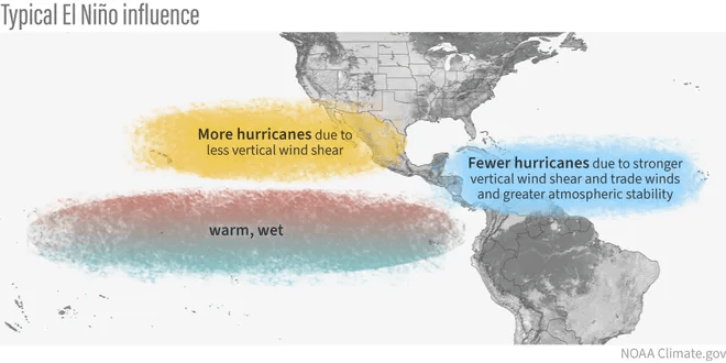
El Niño can significantly impact hurricane seasons in both the Atlantic and Pacific Oceans. Typically, El Niño leads to more rising air over the tropical Pacific, resulting in stronger upper-level wind shear and sinking air across the tropical Atlantic. This usually reduces the number of hurricanes in the Atlantic, especially in the Caribbean and Gulf regions. Conversely, El Niño years are typically associated with increased activity in the eastern Pacific.
During an El Niño winter, the southern third of the United States often experiences wetter-than-average conditions, while the northern third sees enhanced chances of below-normal precipitation. A strong to super El Niño can bring significant storms to the West Coast and a robust southern storm track, rich with moisture from the Gulf and Atlantic, leading to powerful East Coast storms.
The ENSO cycle is a primary factor considered by government scientists when announcing winter weather forecasts, as it mainly influences weather during the colder months. Except for its impact on hurricanes, El Niño doesn't have a strong summer climate impact for most of the country. Seasonal forecasts for El Niño and La Niña help avert millions of dollars in economic losses and are essential planning tools for climate-sensitive sectors like agriculture, health, energy, and water management. They are also crucial for supporting humanitarian operations and disaster risk management, thereby saving lives. |
0 Comments
Join the conversation
Be the first to comment
Share your thoughts above.